


Epicenter Estimation of Landslide
Epicenter estimation of volcanic tremors and landslides using the amplitude spatial variation of seismic waves
Earthquake locations are determined from the arrival times of P or other waves at seismic stations. There is a clear onset in record for an earthquake in record, but landslides and volcanic tremors associated with fluid motion under volcanoes exhibit long monotonous seismic waveforms. This is why we cannot estimate locations of these events even at all with seismic data alone.
Fault motions of earthquakes radiate seismic waves highly anisotropic (i.e., different values when measured in different directions), as opposed to that of a nuclear explosion, for example. High frequency seismic waves (> several Hz) are, however, scattered severely by small-scale heterogeneities abundant in shallow regions, resulting in the smearing of this anisotropy. The effect is particularly strong in volcanic regions with an abundance of heterogeneities near the surface. In such cases, the observed amplitude of seismic waves can be viewed as a simple function of the distance between the source and each station. Based on this assumption, we can estimate the locations of volcanic tremors and landslides.
In the 2008 eruption of Meakandake Volcano in the eastern Hokkaido region, Japan, seismic waves with amplitudes of 5-10 Hz were recorded at five nearby seismic stations. The locations of volcanic tremors associated with the eruption were estimated in the south of the 96-1 crater where the eruption took place at a depth of about 1 km with subsequent northeastern migration toward shallower regions.
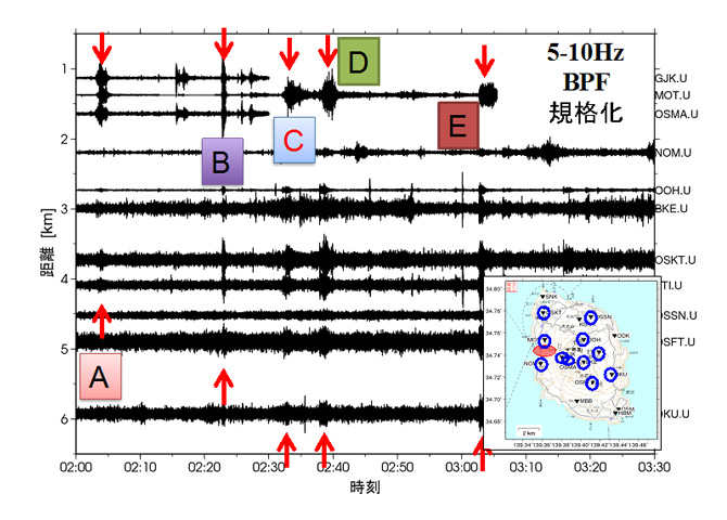
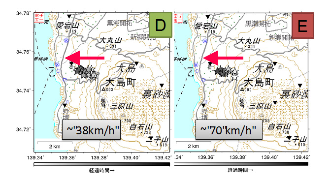
Another case study focuses on a landslide on Izu Oshima, a volcanic island south of Tokyo, caused by heavy rainfall associated with the approach Typhoon No. 26, early on the morning of 26 October 2013, resulting in massive casualties. Seismic stations on the island recorded repeating seismic motions simultaneously (see the left figure). Source determination based on the spatial distribution of these amplitudes agrees with the location where the landslide occurred. The subsequent location estimated at every five seconds shows westward (downhill) migration within each event (right, from the white stars to the black) at a speed of several tens of km/h. The whole landslide consists of at least five major events, each involving westward migration.
(K. Yomogida)
Reference:
Ogiso, M., and K. Yomogida, Migration of tremor locations before the 2008 eruption of Meakandake Volcano, Hokkaido, Japan, J. Volcanology Geotherm.Res., doi:10.1016/j.jvolgeores.2011.12.005,217-218, 8–20, 2012.
Upper Mantle Beneath Japan
3D shear wave structure and radial anisotropy beneath the Japanese archipelago and the surrounding region
The three-dimensional shear wave speed model of the upper mantle beneath the Japanese archipelago and the surrounding regions was reconstructed via inter-station phase-speed measurements of surface waves. To collect the surface-wave dispersion data, three seismographic networks were employed; a dense broadband seismic network (F-net) in Japan, a temporary broadband seismic network in Far-East Russia, and permanent global seismic network stations in East Asia. Using the waveform data from seismic events occurring between 2005 and 2007 with moment magnitudes greater than 6.0 and depths less than 100 km, the phase speeds of fundamental-mode Rayleigh and Love waves were measured using the conventional two-station technique. Phase speed maps of the Japanese archipelago and the Sea of Japan were obtained from the inversion of inter-station phase speeds measured for a large number of station pairs; i.e., over 5,300 paths for Rayleigh waves and 3,800 paths for Love waves. For the phase speed maps of Rayleigh waves, data within the period range from 25 to 140 s were inverted to create an isotropic 3D shear wave speed model for the depth range from 40 to 200 km. The phase speed maps of Rayleigh and Love waves in the period range from 30 to 80 s were also inverted simultaneously for the creation of a radially anisotropic shear wave speed model. The isotropic S wave model (and SV wave model) represents prominent fast wave speed anomalies in northeastern Japan associated with the subducting Pacific Plate. Fast anomalies of the lithosphere beneath the Sea of Japan were also imaged, with results implying that the average thickness of the lithosphere beneath the Yamato Rise and the Japan Basin is about 60 ± 10 km. Immediately below this oceanic lithosphere, slow anomalies are found in the asthenosphere beneath the entire region of the Sea of Japan at depths down to about 200 km. In southwestern Japan, the low-angle subduction of the Philippine Sea Plate was mapped clearly, indicating that the northern end of the plate extends beyond the northern coast of the Chugoku region, reaching beneath the Oki Islands in the Sea of Japan. A strong low-velocity anomaly off the western coast of Kyushu is found at depths down to about 130 km, which suggests the presence of an upwelling flow beneath this area. Remarkable anisotropy with SH > SV is found in the mantle wedge beneath northeastern Japan, while only weak anisotropy is seen beneath the Sea of Japan. Such anisotropic properties, which cannot readily be determined from body wave studies alone, are expected to be important in clarifying the dynamic processes of this tectonically active region.
(K. Yoshizawa)

Reference:
Yoshizawa, K., K. Miyake and K. Yomogida (2010), 3D upper mantle structure beneath Japan and its surrounding region from inter-station dispersion measurements of surface waves, Phys. Earth Planet. Inter., 183, 4 – 19.
Bottom of Continental Plate
3D mapping of the lithosphere-asthenosphere boundary beneath Australia
A 3-D shear wave model incorporating radial anisotropy has been created from a set of multi-mode phase speed maps for Love and Rayleigh waves. These maps are derived from an iterative inversion scheme incorporating the effects of ray-path bending caused by lateral heterogeneity, as well as the finite frequency of the surface waves for each mode. The SV wave speed model (Fig. 1) highlights the major tectonic features of this region, which show close agreement with those of earlier shear wave models derived primarily from Rayleigh waves (i.e., fast wave speed anomalies in the Archean and Proterozoic cratons and slow anomalies in the Phanerozoic eastern margin). Estimation of lateral variations in the depth and thickness of the lithosphere-asthenosphere transition (LAT) from the SV wave speed model and its vertical gradient showed correlations between lateral variations of the LAT and radial anisotropy. As shown in Fig. 2, the LAT is very thick beneath the Archean cratons in western Australia and thinner in the suture zone between cratons. Anomalously faster SH waves are found both above and beneath the relatively thinner (or sharper) LAT in central Australia, suggesting frozen anisotropy in the lithosphere beneath the Mesoproterozoic suture zone and anisotropy induced by shear flow in the asthenosphere beneath the fast-drifting Australian continent.
(K. Yoshizawa)
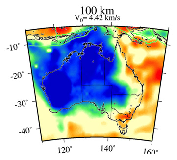 Fig. 1
 Fig. 2
Diversity of Megathrust Earthquakes
Diversity of megathrust earthquakes as revealed by the 2011 Tohoku-Oki earthquake
The great M9.0 earthquake on 11 March 2011 off the coast of the Tohoku district was the largest event ever recorded in and around Japan, and the excited huge tsunami resulted in massive casualties in coastal areas of the region. In this area, the Pacific plate subducts beneath the Japanese archipelago in the Japan Trench at a rate of 8 cm/year, creating cumulative strain on its plate boundary manifested by high seismicity, including repeated earthquakes with magnitude of around M7. The 2011 earthquake was, however, nearly 200 times larger than the previous ones in terms of seismic moment (M0), with a fault area of 200 x 400 km2 and slips of up to nearly 100 m.
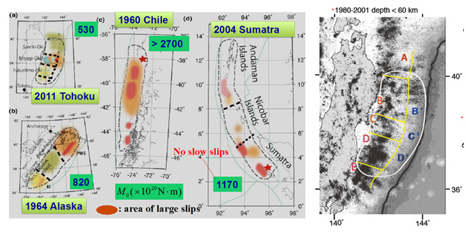
Great megathrust earthquakes measuring over M9 (e.g., 1960 Chile, 1964 Alaska and 2004 Sumatra earthquakes) have been considered “big” simply because a large number of fault segments are interacted to become one large fault in the direction of a subduction zone or trench axis. A same-scale comparison of other great earthquakes with the 2011 Tohoku-Oki earthquake clearly shows how different they are (left figure). The Sumatra earthquake was very long along its trench, extending over 12,000 km while the fault of the Tohoku-Oki event was very compact but with abnormally large slips near its trench.
Inter-seismic activity in the region of a great earthquake covers the area from its trench axis to a deep part, with a quiescence period prior to the great one, as a sole stereotype. In contrast, there were double segmentations along the dip or perpendicular to its subduction axis in the case of Tohoku, with high inter-seismic activity and repeated M7 earthquakes (C on the right) in deep segments versus virtually no seismicity in shallow ones (C’). The very large slips observed in the Tohoku-Oki earthquake corresponded to shallow segments, implying long-term strain accumulation there. This double-segmentation pattern was not seen in the cases of Sumatra and Chile while the northeastern part of the fault in the Alaska event where large slips were estimated shared this feature.
In summary, the Sumatra earthquake involved the rupture of single segments along its subduction axis, as did the Chile earthquake but with large slip areas. Part of the Alaska earthquake area was double-segmented along the dip, and this double segmentation was clearly dominant in the Tohoku-Oki earthquake. Recognition of this diversity in megathrust earthquakes (as opposed to the conventional idea of a large fault with many associated segments) will support re-examination of past great earthquakes and the search for possible subduction zones warning of great ones in the future (e.g., on the Pacific coast of southeastern Hokkaido in Japan).
(K. Yomogida)
Reference:
Yomogida, K., K. Yoshizawa, J. Koyama, and M. Tsuzuki, Along-dip segmentation of the 2011 off the Pacific coast of Tohoku Earthquake and comparison with other megathrust earthquakes, Earth Planets Space, 63, 697-701, 2011.