


- トップページ >
- 雑誌論文 >
- 日置幸介名誉教授
日置幸介名誉教授
2020-現在
Zheng, S., K. Heki, Z. Zhang, H. Yan, Seasonal crustal movements in NE Japan revisited, Remote Sensing of Environment, 改訂中, 2024.
Heki, K., M. Nakatani, and W. Zhan, Ionospheric changes immediately before the 2008 Wenchuan earthquake, Adv. Space Res., 印刷中, doi:10.1016/j.asr.2024.02.011, 2024.
Moudgill, P. S., S. G. Rao, and K. Heki, Bridging the temporal gaps in GRACE/GRACE–FO terrestrial water storage anomalies over the major Indian river basins using deep learning, Natural Resources Res., doi:10.1007/s11053-024-10312-w, 2024.
Heki, K., Atmospheric resonant oscillations by the 2022 January 15 eruption of the Hunga-Tonga Hunga-Ha'apai volcano from GNSS-TEC observations, Geophys. J. Int., 236, 1840-1847, doi:10.1093/gji/ggae023, 2024.
Tiwari, S. H., M. S. Bagiya, S. Maurya, K. Heki, and A. P. Dimri, On the role of volcanic plume heights in the excitation of free oscillations of the solid earth and the atmosphere: case study, Adv. Space Res., 73, 2988-2998, doi:10.1016/j.asr.2024.01.001, 2024.
Muafiry, I. N., D. D. Wijaya, I. Meilano, and K. Heki, Diverse ionospheric disturbances by the 2022 Hunga Tonga-Hunga Ha'apai eruption observed by a dense GNSS array in New Zealand, J. Geophys. Res. Space Phys., 128, e2023JA031486, doi:10.1029/2023JA031486, 2023.
Bagiya, M. S., K. Heki, and V. K. Gahalaut, Anisotropy of the near-field coseismic ionospheric perturbation amplitudes reflecting the source process: The 2023 February Turkey earthquakes, Geophys. Res. Lett., 50, e2023GL103931, doi:10.1029/2023GL103931, 2023.
Heki, K., and S. Jin, Geodetic studies on earth surface loading with GNSS and GRACE, Satellite Navigation, 4:24, doi:10.1186/s43020-023-00113-6, 2023.
Zheng, S., K. Heki, Z. Zhang, Y. Tokui, and H. Yan, Interference of ocean and land mass changes in seasonal crustal deformation of coastal stations: A case study in norhern Australia, Earth Planet. Sci. Lett., 614, 118212, doi:10.1016/j.epsl.2023.118212, 2023.
Heki, K., M.S. Bagiya, and Y. Takasaka, Slow fault slip signatures in coseismic ionospheric disturbances, Geophys. Res. Lett., 49, e2022GL101064, doi:10.1029/2022GL101064, 2022.
Muafiry, I.N., I. Meilano, K. Heki, D. D. Wijaya, and K. A. Nugraha, Ionospheric disturbances after the 2022 Hunga Tonga-Hunga Ha'apai eruption above Indonesia from GNSS-TEC observations, Atmosphere, 13, 1615, doi:10.3390/atmos13101615, 2022.
Hata, S., S. Sugiyama, and K. Heki, Abrupt drainage of Lago Greve, a large proglacial lake in Chilean Patagonia, observed by satellite in 2020, Comm. Earth Environment, 3, 190, doi:10.1038/s43247-022-00531-5, 2022.
Heki, K., Ionospheric signatures of repeated passages of atmospheric waves by the 2022 Jan. 15 Hunga Tonga-Hunga Ha'apai eruption detected by QZSS-TEC observations in Japan, Earth, Planets and Space, 74:112, doi:10.1186/s40623-022-01674-7, 2022.
He, L., L. Wu, K. Heki, and C. Guo, The conjugated ionospheric anomalies preceding the 2011 Tohoku-Oki earthquake, Front. Earth Sci., doi:10.3389/feart.2022.850078, Front. Earth Sci., 10, 850078, doi:10.3389/feart.2022.850078, 2022.
Heki, K. and T. Fujimoto, Atmospheric modes excited by the 2021 August eruption of the Fukutoku-Okanoba volcano, Izu-Bonin Arc, observed as harmonic TEC oscillations by QZSS, Earth Planets Space, 74, 27, doi:10.1186/s40623-022-01587-5, 2022.
Heki, K. and S. Arief, Crustal response to heavy rains in Southwest Japan 2017-2020, Earth Planet. Sci. Lett.,578, doi:10.1016/j.epsl.2021.117325, 2022.
Cahyadi, M.N., E. Y. Handoko, R.W. Rahayu, and K. Heki, Comparison of volcanic explosions in Japan using impulsive ionospheric disturbances, Earth, Planets Space, 73, 228.doi:10.1186/s40623-021-01539-5, 2021.
Zhan, W., K. Heki, S. Arief, and M. Yoshida, Topographic amplification of crustal subsidence by the rainwater load of the 2019 typhoon Hagibis in Japan, J. Geophys. Res. Solid Earth,126, 6号 doi:10.1029/2021JB021845, 2021.
Heki, K., Chapter 21: Ionospheric Disturbances Related to Earthquakes in Ionospheric Dynamics and Applications, Geophys. Monograph, 260, edited by C. Huang, G. Lu, Y. Zhang, and L. J. Paxton, pp.511-526, Wiley/American Geophysical Union, ISBN:978-1-119-50755-0, doi:10.1002/9781119815617.ch21,2021.
Kundu, B., B. Senapati, A. Matsushita,and K. Heki, Atmospheric wave energy of the 2020 August 4 explosion in Beirut, Lebanon, from ionospheric disturbances, Sci. Rep., 11, 2793, 2021.
Yuzariyadi, M. and K. Heki, Enhancement of interplate coupling in adjacent segments after recent megathrust earthquakes, Tectonophys., doi:10.1016/j.tecto.2021.228719, 2021.
Cahyadi, M.N., R.W. Rahayu, K. Heki, and Y. Nakashima, Harmonic ionospheric oscillation by the 2010 eruption of the Merapi volcano, Indonesia, J. Volcanol. Geothermal Res.,405, 107047, 2020.
Muafiry, I.N.and K. Heki, 3D tomography of the ionospheric anomalies immediately before and after the 2011 Tohoku-oki (Mw9.0) earthquake, J. Geophys. Res. Space Phys., 125, doi:10.1029/2020JA027993, 2020.
Arief, S. and K. Heki, GNSS meteorology for disastrous rainfalls in 2017-2019 summer in SW Japan: A new approach utilizing atmospheric delay gradients, Front. Earth Sci., 8, 182, doi:10.3389/feart.2020.00182,2020.
Yi, S., C. Song, K. Heki, S. Kang, Q. Wang, and L. Chang, Substantial meltwater contribution to the Brahmaputra revealed by satellite gravimetry, The Cryosphere, 14, , 2267-2281, doi:10.5194/tc-14-2267-2020.
Heki, K., Geodesy in Japan: Legends and highlights, Earth Planets Space, 72:38, doi:10.1186/s40623-020-01164-8, 2020.
Enomoto,Y., K. Heki, T. Yamabe, S. Sugiura, and H. Kondo, A possible causal mechanism of geomagnetic variations as observed immediately before and after the 2011 Tohoku-oki earthquake, Open J. Earthq. Res., 9, 33-49, doi:10.4236/ojer.2020.92003, 2020.
Yi, S. and K. Heki, Heterogeneous oceanic mass distribution in GRACE observations and its leakage effect, Geophys. J. Int.221, 603-616, doi:10.1093/gji/ggaa022,2020.
2010-2019
橋本繭未、日置幸介、GNSS-TEC観測によるミサイルまたはロケットの推力の評価、測地学会誌、64, 51-55, doi:10.11366/sokuchi.64.51, 2018
He, L., K. Heki,and L. Wu, Three-dimensional and trans-hemispheric ionospheric electron density changes by the great Solar eclipse in North America on 21 August 2017, Geophys. Res. Lett. 45, 10,933-10,940, doi:10.1029/2018GL080365, 2018.
He, L. and K. Heki, Three-dimensional tomography of ionospheric anomalies immediately before the 2015 Illapel earthquake, central Chile, J. Geophys. Res. Space Phys.,123, doi:10.1029/2017JA024871, 2018.
日置幸介, 第5.6章 地球重力場と時間変化, 地球科学の事典 (鳥海光弘他編集), 朝倉書店, pp.248, 2018.
Muafiry, I. N., K. Heki, and J. Maeda, 3D tomography of mid-latitude sporadic-E in Japan from GNSS-TEC data, Earth Planets Space,70, 45, doi:10.1186/s40623-018-0815-7, 2018.
Furuya, M., T. Suzuki, J. Maeda, and K. Heki, Midlatitude Sporadic-E episodes viewed by L-band split-spectrum InSAR,Earth Planets Space, 69, 175, doi:10.1186/s40623-017-0764-6, 2017.
Yi, S., K. Heki, and A. Qian, Acceleration in the global sea level rise: 2005-2015, Geophys. Res. Lett., 44, 11,905-11,913, doi:10.1002/2017GL076129, 2017.
Tu, Yoko. and K. Heki, Decadal modulation of repeating slow slip event activity in the southwestern Ryukyu Arc possibly driven by rifting episodes at the Okinawa Trough, Geophys. Res. Lett., 44, 9308-9313, doi:10.1002/2017GL074455, 2017.
Yi, S., C. Song, Q. Wang, K. Heki, and W. Sun, The potential of GRACE gravimetry to detect the heavy rainfall-induced impoundment of a small reservoir in the upper Yellow River, Water Resources Res., 53, 6562-6578, doi:10.1002/2017WR020793,2017.
He, L. and K. Heki, Ionospheric anomalies immediately before Mw 7.0-8.0 earthquakes, J. Geophys. Res. Space Phys.122, 8659–8678, doi:10.1002/2017JA024012, 2017.
Arisa, D. and K. Heki, Space geodetic observations of repeating slow slip events beneath the Bonin Islands, Geophys. J. Int., 210, 1494-1502, doi:10.1093/gji/ggx258, 2017.
Kelley, M. C., W. E. Swartz, and K. Heki, Apparent ionospheric total electron content variations prior to major earthquakes due to electric fields created by tectonic stresses, J. Geophys. Res. Space Phys., 122, 6689-6695, doi:10.1002/2016JA023601, 2017.
Wang, W. and K. Heki, Subsurface structures of buried features in lunar Procellarum region, Icarus,291, 75-81, doi:10.1016/j.icarus.2017.03.025, 2017.
田中優作、日置幸介、GRACE地震学ー衛星重力観測による地震研究のこれまでとこれからー、地震2、第69巻、pp.69-85, 2017.
He, L. and K. Heki, Three-dimensional distribution of ionospheric anomalies prior to three large earthquakes in Chile, Geophys. Res. Lett., 43, 7287-7293, doi:10.1002/2016GL069863, 2016.
Arisa, D. and K. Heki, Transient crustal movement in the northern Izu-Bonin arc starting in 2004: A large slow slip event or a slow back-arc rifting event?, Tectonophys. 682, 206-213, doi:10.1016/j.tecto.2016.05.029, 2016.
Drouin, V. J.-P., K. Heki, F. Sigmundsson, S. Hreinsdottir, and B. G. Ofeigsson, Constraints on seasonal load variations and regional rigidity from continuous GPS measurements in Iceland, 1997-2014, Geophys. J. Int., 205, 1843-1858, doi:10.1093/gji/ggw122, 2016.
三枝優輝、日置幸介、地形と重力場の全球アドミッタンスからみた月の弾性体厚さ、測地学会誌、61, 167-171, 2016(2015).
Maeda, J., T. Suzuki, M. Furuya, and K. Heki, Imaging the midlatitude sporadic-E plasma patches with a coordinated observation of space-borne InSAR and GPS total electron content, Geophys. Res. Lett., 43, 1419–1425, doi:10.1002/2015GL067585, 2016.
Nakashima, Y., K. Heki, A. Takeo, M. N. Cahyadi, A. Aditiya, and K. Yoshizawa, Atmospheric resonant oscillations by the 2014 eruption of the Kelud volcano, Indonesia, observed with the ionospheric Total Electron Contents and seismic signal, Earth Planet. Sci. Lett., 434, 112-116, 2016.
Heki, K. and Y. Enomoto, Mw dependence of the preseismic ionospheric electron enhancements, J. Geophys. Res. Space Phys., 120, 7006-7020, doi:10.1002/2015JA021353, 2015.
Tanimoto, T., K. Heki, and J. Artru-Lambin, Interaction of Solid Earth, Atmosphere, and Ionosphere. in Treatise on Geophysics, 2nd edition, Vol 4., edited by Gerald Schubert, Oxford: Elsevier, pp. 421-443, 2015.
Maeda, J. and K. Heki, Morphology and dynamics of daytime mid-latitude sporadic-E patches revealed by GPS total electron content observations in Japan, Earth Planets Space, 67, 89, doi:10.1186/s40623-015-0257-4, 2015.
Yi, S., W. Sun, K. Heki, and A. Qian, An increase in the rate of global mean sea level rise since 2010, Geophys. Res. Lett., 42 doi:10.1002/2015GL063902, 2015.
Tanaka, Y., K. Heki, K. Matsuo, and N. V. Shestakov, Crustal subsidence observed by GRACE after the 2013 Okhotsk deep-focus earthquake, Geophys. Res. Lett., 42, doi:10.1002/2015GL063838, 2015.
Mitsui, Y. and K. Heki, Report on a characteristic oscillation about 38 mHz (26 s) in Northeastern Japan following surface wave of the 2011 Tohoku megathrust earthquake, Geophys. J. Int., 202, 419-423, doi:10.1093/gji/ggv147, 2015.
Kuo, C. L., L. C. Lee, and K. Heki, Preseismic TEC changes for Tohoku-Oki earthquake: Comparisons between simulations and observations, Terr. Atmos. Ocean. Sci.,26, 63-72, 2015.
日置幸介、測位衛星で見る地殻変動、パリディ、30(4), 2015.
Cahyadi, M. N. and K. Heki, Coseismic ionospheric disturbance of the large strike-slip earthquakes in North Sumatra in 2012: Mw dependence of the disturbance amplitudes, Geophys. J. Int., 200, 116-129, 2015.
Heki, K. and Y. Enomoto, Reply to comment by K. Heki and Y. Enomoto on "Preseismic ionospheric electron enhancements revisited", J. Geophys. Res. Space Phys., 119,doi:10.1002/2014JA020223, 2014.
Nakashima, Y. and K. Heki, Ionospheric hole made by the 2012 North Korean rocket observed with a dense GNSS array in Japan, Radio Sci., 49, doi:10.1002/2014RS005413, 2014.
Tanaka, Y. and K. Heki, Long- and short-term postseismic gravity changes of megathrust earthquakes from satellite gravimetry, Geophys. Res. Lett., 41, 5451-5456, doi:10.1002/2014GL060559, 2014.
橋本実奈、日置幸介、月惑星の重力場におけるカウラの法則とそのスケーリング則、測地学会誌、59, 163-166, 2013.
中島悠貴、日置幸介、マルチパスを用いたGPS潮位計、測地学会誌、59, 157-162, 2013.
松尾功二、日置幸介、アジア高山域の氷河質量収支:衛星重力観測の再考、雪氷、76巻1号、 45-57, 2014.
Maeda, J. and K. Heki, Two-dimensional observations of mid-latitude sporadic-E irregularities with a dense GPS array in Japan, Radio Sci., 49, 1-8, doi:10.1002/2013RS005295, 2014.
Heki, K. and Y. Enomoto, Preseismic ionospheric electron enhancements revisited, J. Geophys. Res., 118, 6618-6626, doi:10.1002/jgra.50578, . 2013.
Matsuo, K., B. F. Chao, T. Otsubo, and K. Heki, Accelerated ice mass depletion revealed by low-degree gravity field from Satellite Laser Ranging: Greenland, 1991-2011, Geophys. Res. Lett., 40, 1-6, doi:10.1002/grl.50900, 2013.
Mitsui, Y. and K. Heki, Scaling of early afterslip velocity and possible detection of tsunami-induced subsidence by GPS measurements immediately after the 2011 Tohoku-Oki earthquake, Geophys. J. Int., 195, 238-248, doi:10.1093/gji/ggt256, 2013.
Matsuo, K. and K. Heki, Current ice loss in small glacier systems of the Arctic Islands from satellite gravimetry, Terr. Atmos. Ocean. Sci., 24, 657-670, doi:10.3319/TAO2013.02.22.01(TibXS), 2013.
Cahyadi, M. N. and K. Heki, Ionospheric disturbances of the 2007 Bengkulu and the 2005 Nias earthquakes, Sumatra, observed with a regional GPS network, J. Geophys. Res., 118, 1-11, doi:10.1002/jgra.50208, 2013.
吉田清人、日置幸介、GPS気候学:日本列島の可降水量の長期的変動、測地学会誌、第58巻, 第4号, 141-152, 2012.
Heki, K. and Y. Mitsui, Accelerated Pacific Plate subduction following interplate thrust earthquakes at the Japan Trench, Earth Planet. Sci. Lett. 363, 44-49, doi:10.1016/j.epsl.2012.12.03, 2013.
Mitsui, Y. and K. Heki, Observation of Earth's free oscillation by dense GPS array: After the 2011 Tohoku megathrust earthquake, Sci. Rep., 2, 931, doi:10.1038/srep00931, 2012.
小林裕太、日置幸介、最近の大地震による極運動の励起について、測地学会誌、 58, 89-93, 2012.
Okazaki, I. and K. Heki, Atmospheric temperature changes by volcanic eruptions: GPS radio occultation observations in the 2010 Icelandic and 2011 Chilean cases, J. Volcanol. Geotherm. Res., 245-246, 123-127, doi:10.1016/j.jvolgeores.2012.08.018, 2012.
Matsuo, K. and K. Heki, Anomalous precipitation signatures of the Arctic Oscillation in the time-variable gravity field by GRACE, Geophys. J. Int., 130, , 1495-1506, doi:10.1111/j.1365-246X.2012.05588.x, 2012.
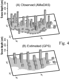
Ozeki, M. and K. Heki, GPS snow depth meter with geometry-free linear combinations of carrier phases, J. Geodesy, 86, 209-219, doi:10.1007/s00190-011-0511-x, 2012.
Matsuo, K. and K. Heki, Coseismic gravity changes of the 2011 Tohoku-Oki Earthquake from satellite gravimetry, Geophys. Res. Lett., 38, L00G12, doi:10.1029/2011GL049018, 2011.
Heki, K., Ionospheric electron enhancement preceding the 2011 Tohoku-Oki earthquake, Geophys. Res. Lett. 38, L17312, doi:10.1029/2011GL047908, 2011.
Astafyeva, E. and K. Heki, Vertical TEC over seismically active region during low solar activity, J. Atm. Solar-Terr. Phys., 73, 1643-1652, 2011.
Heki, K., A tale of two earthquakes, Science, 332, 1390-1391, 2011.
日置幸介、菅原守、大関優、岡崎郁也、GPS-TEC法による地球物理学、測地学会誌, 56 (解説・入門講座)、125-134, 2010.
Ogawa, R., B. F. Chao, and K. Heki, Acceleration signal in GRACE time-variable gravity in relation to interannual hydrological changes, Geophys. J. Int., 184, 673-679, doi:10.1111/j:1365-246X.2010.04843.x, 2011.
Heki, K. and K. Matsuo, Coseismic gravity changes of the 2010 earthquake in Central Chile from satellite gravimetry, Geophys. Res. Lett., 37, L24306, doi:10.1029/2010GL045335, 2010.
Ozeki, M. and K. Heki, Ionospheric holes made by ballistic missiles from North Korea detected with a Japanese dense GPS array, J. Geophys. Res., 115, A09314, doi:10.1029/2010JA015531, 2010.
Matsuo, K. and K. Heki, Time-variable ice loss in Asian high mountains from satellite gravimetry, Earth Planet. Sci. Lett. 290, 30-36, doi:10.1016/j.epsl.2009.11.053, 2010.
2000-2009
Astafyeva, E., K. Heki, V. Kiryushkin, E. Afraimovich, S. Shalimov, Two-mode long-distance propagation of coseismic ionosphere disturbances, J. Geophys. Res., 114, A10307, doi:10.1029/2008JA013853, 2009.
Astafyeva, E. and K. Heki, Dependence of waveform of near-field coseismic ionospheric disturbances on focal mechanisms, Earth Planet. Space, 61, 939-943, 2009.
Matsuo, K. and K. Heki, Seasonal and inter-annual changes of volume density of Martian CO2 snow from time-variable elevation and gravity, Icarus, 202, 90-94, 2009.
菅原守、日置幸介、火星の真の極移動に伴う地殻変動について、測地学会誌、 54, 279-282, 2008.
Heki, K and T. Kataoka, On the biannualy repeating slow slip event at the Ryukyu Trench, Southwest Japan, J. Geophys. Res., 113, B11402, doi:10.1029/2008JB005739, 2008.
Morishita, Y. and K. Heki, Characteristic precipitation patterns of El Nino / La Nina in time-variable gravity fields by GRACE, Earth Planet. Sci. Lett., 272, 677-682, 2008.
Noda, H., K. Heki, and H. Hanada, In situ Lunar Orientation Measurement (ILOM): Simulation of observation, Adv. Space Res., 42, 358-362, 2008.
Furuya, T. and K. Heki, Ionospheric hole behind an ascending rocket observed with a dense GPS array, Earth Planets Space, 60, 235-239, 2008.
日置幸介、電離圏をゆるがす巨大地震、ないふる、63, 4-5、2007.
Heki, K., Secular, transient and seasonal crustal movements in Japan from a dense GPS array: implication for plate dynamics in convergent boundaries, in The Seismogenic Zone of Subduction Thrust Faults edited by T. Dixon and C. Moore, 512-539, Columbia University Press, 2007.
Ogawa, R. and K. Heki, Slow postseismic recovery of geoid depression formed by the 2004 Sumatra-Andaman Earthquake by mantle water diffusion, Geophys. Res. Lett., 34, L06313, doi:10.1029/2007GL029340, 2007.
日置幸介、太陽フレアに伴う電離層全電子数上昇のGPS観測、測地学会誌、 52, 319-328, 2006.
Heki, K., Y. Otsuka, N. Choosakul, N. Hemmakorn, T. Komolmis, and T. Maruyama, Detection of ruptures of Andaman fault segments in the 2004 Great Sumatra Earthquake with coseismic ionospheric disturbances, J. Geophys. Res., 111, B09313, doi:10.1029/2005JB004202, 2006.
Heki, K., Explosion energy of the 2004 eruption of the Asama Volcano, Central Japan, inferred from ionospheric disturbances, Geophys. Res. Lett., 33, L14303, doi:10.1029/2006GL026249, 2006.
日置幸介、地震と荷重の微妙な関係、地震ジャーナル、41, 5-11, 2006.
Goossens, S., P.N.A.M. Visser, K. Heki, and B.A.C. Ambrosius, Local gravity from Lunar Prospector tracking data: results for Mare Serenitatis, Earth Planets Space, 57, 1127-1132, 2005.
Heki, K. and J.-S. Ping, Directivity and apparent velocity of the coseismic ionospheric disturbances observed with a dense GPS array, Earth Planet. Sci. Lett., 236, 845-855, 2005.
Sugano, T. and K. Heki, Isostasy of the Moon from high-resolution gravity and topography data: Implication for its thermal history, Geophys. Res. Lett., 31, L24703, doi:10.1029/2004GL022059, 2005.
Heki, K., Dense GPS array as a new sensor of seasonal changes of surface loads, in The State of the Planet: Frontiers and Challenges in Geophysics, edited by R.S.J. Sparks and C.J. Hawkesworth, Geophys. Monograph, 150, 177-196, American Geophysical Union, Washington, 2004.
Sugano, T. and K. Heki, High resolution lunar gravity anomaly map from the Lunar Prospector line-of-sight acceleration data, Earth Planets Space, 56, 81-85, 2004.
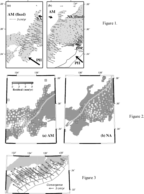
Heki, K., Space geodetic observation of deep basal subduction erosion in northeastern Japan, Earth Planet. Sci. Lett., 219, 13-20, 2004.
Ping, J.-S., K. Heki, K. Matsumoto and Y. Tamura, A degree 180 spherical harmonic model for the Lunar topography, Adv. Space Res., 31, 2377-2382, 2003.
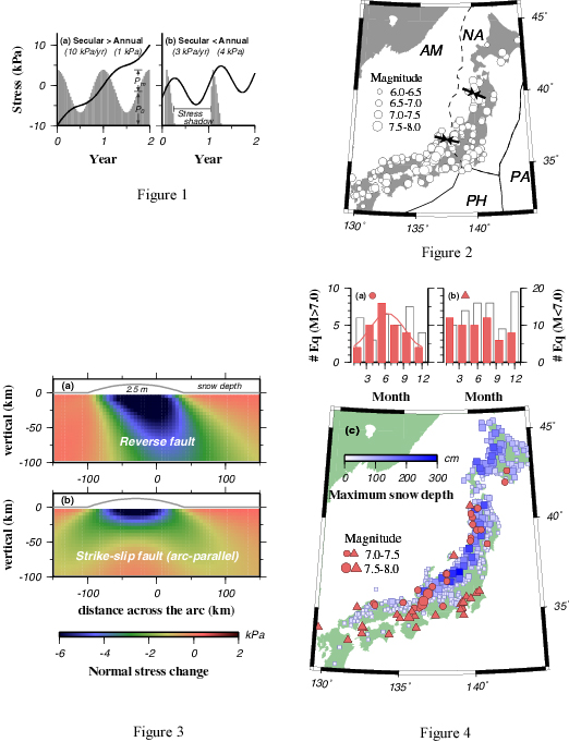
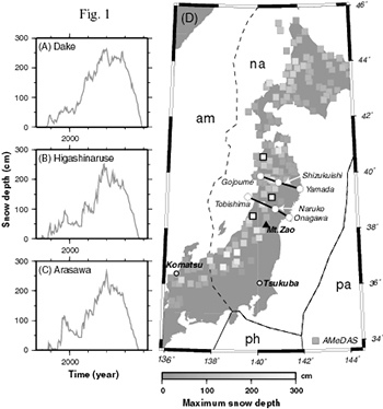
Heki, K., Snow load and seasonal variation of earthquake occurrence in Japan, Earth Planet. Sci. Lett., 207, 159-164, 2003.
Iwabuchi, T., S. Miyazaki, K. Heki, I. Naito and Y. Hatanaka, An impact of estimating tropospheric delay gradients on tropospheric delay estimations in the summer using the Japanese nationwide GPS array, J. Geophys. Res., 108, 4315, doi:10.1029/2002JD002214, 2003.
Miyazaki, S., T. Iwabuchi, K. Heki and I. Naito, An impact of estimating tropospheric gradient on precise positioning in summer using the Japanese nationwide GPS array, J. Geophys. Res., 108, 2335, doi:10.1029/2000JB000113, 2003.
Heki, K., Seasonal modulation of interseismic strain buildup in Northeastern Japan driven by snow loads, Science, 293, 89-92, 2001.
Heki, K. and S. Miyazaki, Plate convergence and long-term crustal deformation in Central Japan, Geophys. Res. Lett., 28, 2313-2316, 2001.
Miyazaki, S. and K. Heki, Crustal velocity field of Southwest Japan: subdution and arc-arc collision, J. Geophys. Res., 106, 4305-4326, 2001.
(被引用回数 100回以上)
1990-1999
Heki, K., S. Miyazaki, H. Takahashi, M. Kasahara, F. Kimata, S. Miura, N. Vasilenco, A. Ivashchenco and K. An, The Amurian plate motion and current plate kinematics in Eastern Asia, J. Geophys. Res., 104, 29147-29155, 1999.
(被引用回数 100回以上)
日置幸介, 地球 : 中身を知る三つの方法, アエラムック, 第52巻, 62-65, 1999.
Matsumoto, K., K. Heki and D. D. Rowlands, Impact of farside satellite tracking on gravity estimation in the SELENE project, Adv. Space Res., 23, 1809-1812, 1999.
Heki, K., K. Matsumoto and R. Floberghagen, Three-dimensional tracking of a lunar satellite with differential very-long-baseline-interferometry, Adv. Space Res., 23, 1821-1824, 1999.
日置幸介、宇宙測地学:大気遅延誤差と局位置誤差の関係、月刊地球、号外25号、 73-77, 1999.
日置幸介、島田誠一、大谷竜、GPS解析ソフトウェア、気象研究ノート、192, 73-92, 1998.
Tsuda, T., K. Heki, S. Miyazaki, K. Aonashi, K. Hirahara, H. Nakamura, M. Tobita, F. Kimata, T. Tabei, T. Matsushima, F. Kimura, M. Satomura, T. Kato and I. Naito, GPS meteorology project of Japan - Exploring frontiers of geodesy -, Earth Planets Space, 50, i-v, 1998.
日置幸介、松本晃治、重力計測による月探査、国立天文台ニュース、68, 7-9, 1998.
Koyama, Y., N. Kurihara, T. Kondo, M. Sekido, Y. Takahashi, H. Kiuchi and K. Heki, Automated geodetic Very Long Baseline Interferometry observation and data analysis system, Earth Planets Space, 50, 709-722, 1998.
日置幸介、測地帯域でみた1994年三陸はるか沖地震、月刊地球、20, 14-18, 1998.
Heki, K. and Y. Tamura, Short term afterslip in the 1994 Sanriku-Haruka-Oki earthquake, Geophys. Res. Lett., 24, 3285-3288, 1997.
日置幸介、プレートの運動と変形の宇宙測地計測、測地学会誌、 43, 1-12, 1997.
Heki, K., S. Miyazaki and H. Tsuji, Silent fault slip following an interplate thrust earthquake at the Japan Trench, Nature, 386, 595-597, 1997.
(被引用回数 200回以上)
Iwabuchi, T., K. Heki and I. Naito, Decadal polar motion connected with atmospheric pressure and sea level patterns over the North Atlantic Ocean, International Association of Geodesy Symposia, Vol. 117: Segawa et al. (eds.), Gravity, Geoid and Marine Geodesy, pp. 666-673, Springer-Verlag, Berlin, 1997.
日置幸介、編集後記、国立天文台ニュース、 49, 18, 1996.
Heki, K., Vertical and horizontal crustal movements from three dimensional VLBI kinematic reference frame: implication for the geomagnetic reversal timescale revision, J. Geophys. Res., 101, 3187-3198, 1996.
Heki, K., Y. Koyama, N. Kawaguchi, J. Amagai, H. Kuroiwa, S. Hama, Qian Z.-H., Ye S.-H., M. Imae, N. Kurihara, Y. Sugimoto, T. Yoshino, F. Takahashi, H. Kiuchi, Y. Takahashi, H. Takaba, T. Iwata, Y. Hanado, M. Sekido, T. Kondo and A. Kaneko, Movement of the Shanghai station: implication for the tectonics of Eastern Asia, J. Comm. Res. Lab., 42, 65-72, 1995.
Foulger, G.R., M.A. Hofton, B.R. Julian, C.-H. Jahn and K. Heki, Regional post-diking deformation in Northeast Iceland: a third epoch of GPS measurement in 1992, J. Geod. Soc. Jpn. (CRCM'93 Proceedings Special Issue), 99-105, 1994.
日置幸介、プレートの動きを測る、"最新・地球学-50億年のダイナミクス"、 朝日ワンテーママガジン、 11, 118-123, 1993.
Heki, K., G.R. Foulger, O. Alp and M. Ergun, The 1989 GPS Campaign in SW Turkey: Data analysis, in Proceedings of XX General Assembly IUGG, Vienna, Austria, 1991, IAG Symposium 109, Permanent Satellite Tracking Networks for Geodesy and Geodynamics, edited by G.L. Mader, Springer Verlag, New York, 131-140, 1993.
日置幸介、上海が近づいてくる、CRLニュース、第203号(1993年2月).
Heki, K., G.R. Foulger, B.R. Julian and C.-H. Jahn, Plate dynamics near divergent boundaries: geophysical implications of postrifting crustal deformation in NE Iceland, J. Geophys. Res., 98, 14279-14297, 1993.
日置幸介、イギリスでの766日、CRLニュース、第198号 (1992年9月).
Heki, K., A network adjustment program for the Bernese Global Positioning System data analysis software, J. Geod. Soc. Japan, 38, 309-312, 1992.
Foulger, G.R., C.-H. Jahn, G. Seeber, P. Einarsson, B.R. Julian and K. Heki, Post-rifting stress relaxation at the divergent plate boundary in Northeast Iceland, Nature, 358, 488-490, 1992.
日置幸介、VLBI技術とその応用、電子情報通信学会誌、 74, 66-73, 1991.
Otsuki, K., K. Heki and T. Yamazaki, New data which support the `laws of convergence rate of plates' proposed by Otsuki, Tectonophysics, 172, 365-368, 1990.
Heki, K., Y. Takahashi and T. Kondo, Contraction of northeastern Japan: evidence from horizontal displacement of a Japanese station in global very long baseline interferometry networks, Tectonophysics, 181, 113-122, 1990.
Heki, K., Three approaches to improve the estimation accuracies of the vertical VLBI station positions, J. Geod. Soc. Japan, 36, 143-154, 1990.
1980-1989
日置幸介、VLBIでみる地球、科学、 59, 316-319, 1989.
Yoshino, T., Y. Takahashi, N. Kawaguchi, K. Heki, K. Yokoyama and S. Manabe, Intercomparison of the earth rotation parameters determined by two independent VLBI networks, Astron. Astrophys., 224, 316-320, 1989.
Heki, K., Y. Takahashi and T. Kondo, The baseline length changes of circumpacific VLBI networks and their bearing on global tectonics, IEEE Trans. Instr. Meas., 38, 680-683, 1989.
Heki, K., Y. Takahashi, T. Kondo, N. Kawaguchi, F. Takahashi and N. Kawano, The relative movement of the North American and Pacific plates in 1984-1985, detected by the Pacific VLBI network, Tectonophysics, 144, 151-158, 1987.
Kono, M., K. Heki and Y. Hamano, Paleomagnetic study of the Central Andes: counterclockwise rotation of the Peruvian Block, J. Geodynamics, 2, 193-209, 1985.
Tsunakawa, H., K. Heki and K. Amano, Paleomagnetism of the Shimokura dike swarm in Northeast Japan, J. Geomag. Geoelectr., 37, 979-985, 1985.
日置幸介、VLBIと岩石磁気、RRLニュース, 第112号(1985年7月).
Heki, K., Y. Hamano, M. Kono and T. Ui, Palaeomagnetism of Neogene Ocros dyke swarm, the Peruvian Andes: implication for the Bolivian orocline, Geophys. J. R. Astr. Soc., 80, 527-534, 1985.
Heki, K., Y. Hamano and M. Kono, Paleomagnetic study of the Cretaceous Atajana Formation and the Arica dike swarm, Northernmost Chile, J. Geomag. Geoelectr., 37, 107-117, 1985.
Heki, K., The inverse problem of instantaneous plate kinematics by using VLBI network, Rock Mag. Paleogeophys., 11, 120-124, 1984.
日置幸介、浜野洋三、河野長、古地磁気から見た中部アンデスの折れ曲がり、 月刊地球、6, 621-629, 1984.
Heki, K., Y. Hamano, H. Kinoshita, A. Taira and M. Kono, Paleomagnetic study of Cretaceous rocks of Peru, South America: evidence for rotation of the Andes, Tectonophysics, 108, 267-281, 1984.
Heki, K., Y. Hamano and M. Kono, Rotation of the Peruvian Block from palaeomagnetic studies of the Central Andes, Nature, 305, 514-516, 1983.

![]()
Heki, K. Space Geodetic Observation of Deep Basal Subduction Erosion in Northeastern Japan
Earth Planet. Sci. Lett., 219, 13-20, 2004.
三陸海岸は典型的なリアス式海岸であり、大地の長年にわたる沈降によって形成 されたといわれています。東北日本弧の前弧(太平洋側)のGPSデータは、地震間 地震時の両方で沈降を示し、この地域の上下動が地震サイクルでの和がゼロでなく 負になっていることを物語っており、沈降海岸の地形とも調和的です。一方西南 日本弧では地震サイクル毎に室戸岬などの突端は隆起してゆくことが知られています。 この違いを理解するために、島弧に直交する方向の速度断面をとり、鉛直および 水平速度を海溝からの距離の関数として表し、沈み込み帯の速度場の説明に従来 用いられているすべり欠損モデルの予測との比較を行いました。 その結果西南日本では上下、鉛直ともほぼ観測された速度はモデ ルに一致、一方東北日本では水平速度はモデルと良く一致するものの、鉛直速度 に関してはモデルは太平洋岸では隆起を予測するのに現実は沈降しており、鉛直 速度が有意に負にずれることが見いだされました。その原因として本論文では造 構性侵食(subduction erosion 又はtectonic erosion)との関連を論じています。 これは1973年に小松左京の「日本沈没」で日本を沈没させた過程がゆっくりでは あるが現実に進行していることを示唆しています。
Observation of tectonic erosion in a subduction zone has been difficult as it leaves little geological and geophysical evidence. Three-dimensional velocity profiles of crustal movement obtained by Global Positioning System (GPS) across the northeastern Japan (NEJ) and southwestern Japan (SWJ) agree well with those predicted by the elastic loading of the subducting slabs. However, vertical velocities in the NEJ forearc show significant negative deviation (relative subsidence). This may indicate loss of material at the plate interface that can be attributed to the erosion of the upper plate by the underthrusting slab (basal subduction erosion). The estimated rate (15 mm/yr down to a slab depth of 90 km) is somewhat faster than the geological average; the erosion speed may be variable being controlled by the surface roughness of subducting slabs.